Wednesday, November 26, 2014

Skirting the Weather

One of the nice things about our anchorage in Clearwater was that there is dinghy access to a Publix Supermarket which we took advantage of. Pam was nearly out of half & half so all things stopped until the supply could be replenished!

The dinghy dock is to the right of the Aquarium and we anchored in the scalloped out area just under the blue aquarium emblem.

An aerial view of Clearwater Pass and surrounding area. The anchorage was above the causeway that runs from the mainland to the beach.

Monday morning with the wind predicted to increase steadily throughout the day we got underway with the goal to get across Tampa Bay before it got ugly. Before we got too far though we decided to take advantage of the free pumpout available at the city owned Clearwater Harbor Marina right under the causeway and along the ICW. Very convenient.

 Nothing says fun like a free pumpout!

Our travel down the ICW from Clearwater was dotted with bridges. Most of them we could fit under without lowering the antenna. Some we could make by lowering it. The tense part comes in reading the sign board on the bridge bulkhead that displays the clearance. It's usually facing the side of the channel and is not plainly visible till your close. Additionally there is at most bridges a smaller sign that indicates an additional 3' to 4' of clearance at the center span. Again you can not read it until you are right next to it.

So by now you're thinking....just radio the bridge tender and ask the clearance. Good idea! Only problem is, as I found out later, that according to one bridge tender they can not give out that information! Ridiculous.

The bridge we came under yesterday coming in from the Gulf. Plenty of clearance.

Our travel down the ICW was pretty quiet today with only a couple of other boats on the waterway. Shortly before getting to Tampa Bay we were again entertained by the dolphins.

They love to entertain.

Pam talking to the dolphins.

As we ran along the approach to the Sunshine Skyway we watched the kite surfers taking advantage of the blustery winds.

Kite surfing along the Skyway.

Once we cleared the land barriers we were met by 3' seas. Fortunately they were directly on our bow as we made our way across the bay to the more protected waters on the south side.

Again bridges dotted the way and by now the rain had started along with the wind. Not the best of situations when you have to idle around waiting for a scheduled opening of the bridge. Fortunately we fit under the first one (after some discussion about clearance with the bridge tender) and with a burst of speed from Tourist we were able to arrive at the second bridge in time for their opening. It was only later that I learned from another tender that they could not divulge the top secret information about the clearances.

We worked our way south while listening to the deteriorating weather forecast on the vhf. Again we had wanted to anchor but decided to take shelter at Marina Jack's (www.marinajacks.com) in Sarasota for a couple of nights.

Our arrival was just in time to get Tourist secured and plugged in to the umbilical cord before the wind increased and more rain started to fall. We did manage to get to the office and pay for our slip without getting wet thus avoiding a "Pamick" moment due to wet hair!

One of our neighboring boats was a rather large Hatteras that Pam thinks should be our next boat.

Notice the name.

While in Sarasota we managed to catch up on laundry. Get our nails done. And found a great burger at Patrick's (www.Patricks1481.com) located just a few blocks from the marina in the downtown area. Apparently others have found Patrick's also because by the time we were finished there was a line outside the door waiting for tables.

While walking around we were reminded that Christmas is just around the corner.

We were treated to this nice sunset our 2nd night as we looked from our slip towards the ICW.

By Wednesday the weather cleared enough to get underway. The wind was still blowing with rough seas offshore but the ICW was very tame and a few boats were underway.

Pulling out of Marina Jack's.

Just below Sarasota we passed this see thru home next to the waterway.

It didn't take long to be rudely passed by an express cruiser who just had to get there first. He rocked us pretty good but I had an ace up my sleeve. The Blackburn Bridge.
Too low for the express cruiser to get under meant he needed an opening. Since we were only a couple of miles out I radioed the bridge to request an opening when we got to it. No problem I was told. Keep coming. A couple of minutes later the rude waker called the bridge to get an opening. Sure thing he was told just as soon as the boat behind you gets in range I'll open.    Gotcha!

The Blackburn Bridge and the rude waker. (dark hulled boat)

Our travel took us through Venice and on to an anchorage near Cape Haze that we have used before. As we neared the anchorage Pam & I commented on how during our previous overnights here we were normally alone or maybe shared it with just one other boat. Obviously we should have zipped our lips because by the time the sun set we had 6 boats tucked in beside us and behind us.
Fortunately in this location that's not a problem. In fact there was still room for 2 or 3 more to get in before it would get uncomfortable.

 The sailboats appear farther away than they actually are but still plenty of distance.

Thursday morning we timed our departure to allow us enough time to make the 9 am. opening of the Boca Grande Bridge. Most of the other boats made the 8:30 opening which was fine by us since the area above the bridge isn't all that accommodating for 5 or 6 boats to be circling waiting for the bridge to open.

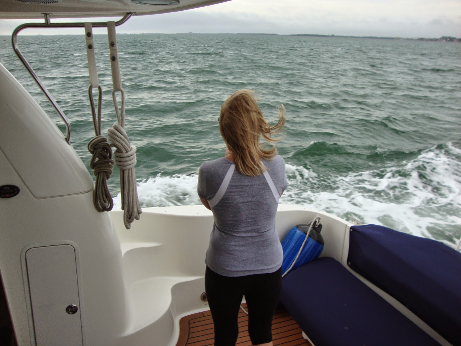
As we made our way south the effects of the East wind became more evident as they blew across Charlotte Harbor. Once we cleared into the open bay the seas were hitting us broadside making for a very rolly ride. Again with an increase in speed we were able to get on top of the waves and have a much more comfortable ride until we ducked in behind Useppa Island. The rest of our ride was pretty smooth as we made our way to our turn to cross the "Miserable Mile" and head up the Caloosahatchie River.
At our first no wake area near Shell Point we were able to catch a view of the Westin at Glover Bight. Pam and I watched the contractors complete this structure a few years ago from our anchorage in the bight and decided to drop the hook once again nearby and enjoy the rest of the day.

The Westin through the mangroves.

We also noticed that the anchored bait shop in the no wake zone had changed from a boat to a floating structure. I guess that's progress.

Fresh Bait!

By the time we anchored the temperature was in the mid-70's with the sun overhead. Time to find a swimsuit! We celebrated our arrival back to what has now become familiar waters with a little cheese and cocktail spread in the cockpit.

Enjoying the warm weather.

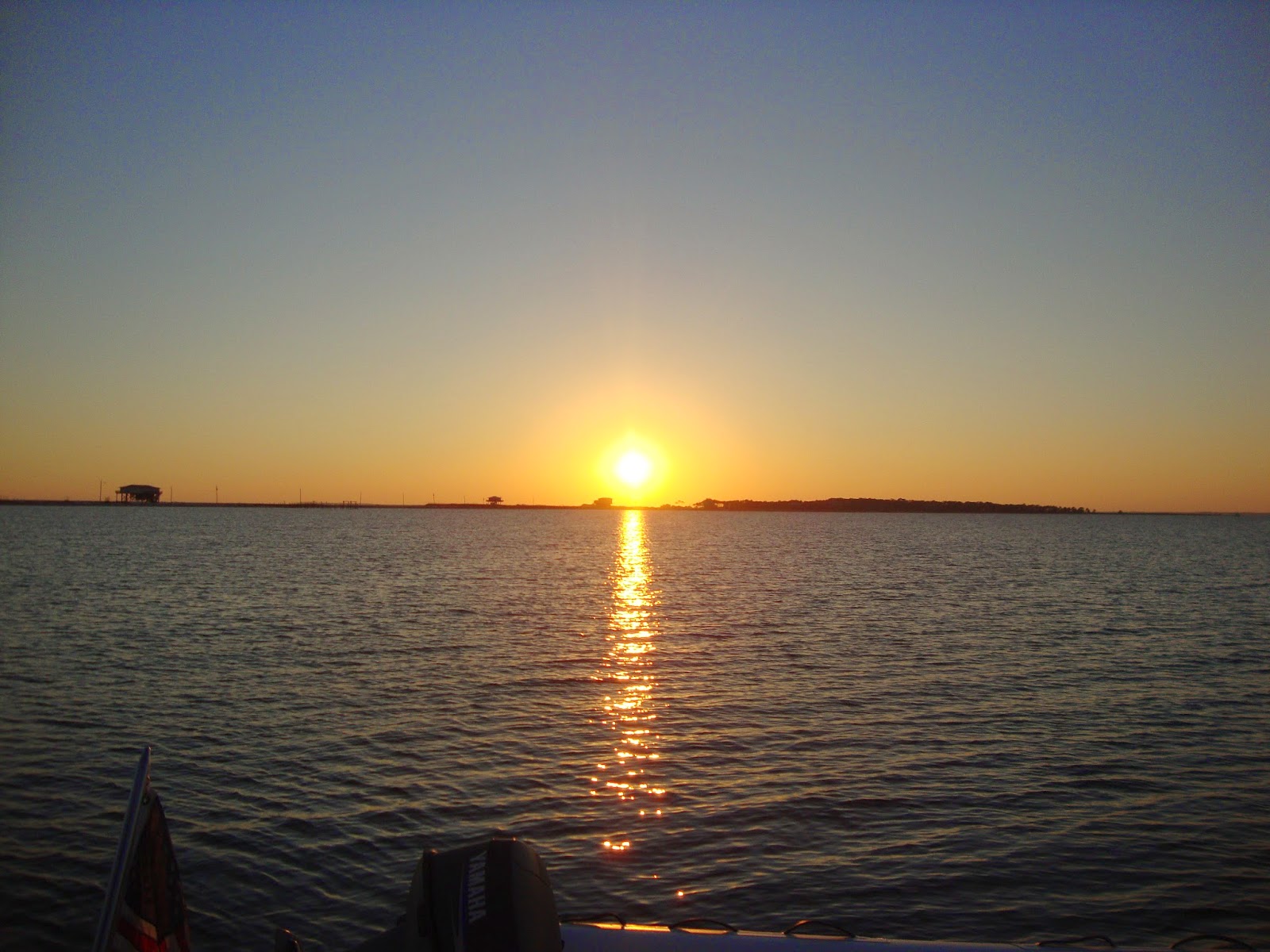
We finished the day with steaks on the grill and a beautiful sunset.

Another sunset over Tarpon Point.

Friday we took our time getting ready since we wanted to look presentable when we arrived at Legacy.

 Pulling the anchor for the last time on this journey.

We had an almost incident free trip upriver to the marina except for one jerk in an identical Sea Ray to ours who came by on plane close enough to shake his hand. Needless to say he rocked the crap out of us before he slowed down a quarter mile later for the minimum wake zone. It's idiots like him that give Sea Rays a bad name. Oh to have a bow cannon!

We knew we were close when we could see the Highpoint Condo Towers.

Legacy looks busy.

B-Dock. Our home for the winter.

As always the staff of Legacy were there to help with lines as well as some of the usual suspects who we share the dock with. It was great to finally get here and start re-connecting with everyone.

Eventually, in what has become a first day tradition for Pam & I, we made our way next door to Joe's Crab Shack for lunch.

Before long after settling in it was time for Docktails! We're here!


Friday, November 21, 2014

The Crossing

Coming down the Tenn-Tom we start thinking about the weather window for crossing the gulf. When we get to the lower section of the waterway and back into wireless internet range we start looking at the various sites that we rely on for wind and wave predictions for the route from Carrabelle to Clearwater. What we find usually dictates how long it will take us to travel from Mobile to Carrabelle. This time was no different.
At first it looked like we would have plenty of time to traverse the gulf coast then a possible opening started to peek out of the forecasts. Each day it looked more and more favorable for even an overnight crossing for the trawlers. With that in mind we made our way across and pulled in to C-Quarters Marina in Carrabelle to top off the fuel tanks before moving out to the staging point of Dog Island by Saturday afternoon.

The anchorage already had a few other boats waiting and a couple more coming out of Apalachicola. Mostly trawlers and 1 sailboat were planning on leaving around 4 pm for an overnighter. The weather was looking better as the hours passed with the winds and waves falling back towards the predicted forecast. Our plan was to get some sleep and head out between 3 and 4 am.

At 4 pm the armada took off. 7 boats in total. I listened on the vhf to their conversations as they entered the gulf and while it sounded a bit rocky no one was complaining as they tinkered with their course to find the smoothest ride. Eventually they were out of vhf range and into the night. Time for some shuteye.

We anchor in the lower left corner of Dog Island for a quick trip around the corner to enter the Gulf through East Pass.

As night progressed in the anchorage the wind shifted direction which made sleeping nearly impossible. Soon enough it was go time. During our time at anchor the skies went from clear to cloudy with a mist in the air as we contemplated to go or stay. We weighed the options and decided to get moving. The forecast was still good. 2' or less for most of the trip showing on all of the weather sites well into Sunday night.

Tourists spotlight came in handy as we picked out the buoys going out East Pass. With the mist and the clouds it was blacker than the inside of a cow and not all of the buoys are lighted. We knew it was going to be fun once we passed the outer marker and turned toward Clearwater. The less than 2 footers were more like 3 footers on the beam causing us to roll back and forth uncomfortably. A change in course toward the Crystal River buoy and a slight increase in speed to get the bow up helped ease the rolling. Still the spray was dousing the flybridge as Tourist plowed forward through the dark.

On we went for the next hours until the sun came up not risking leaving the bridge even to use the head while we were in the washing machine. And no. Neither one of us had an accident during that time! Once we had daylight we could at least see what may be coming at us and take precautions.

We dickered with our course and settled on a route between Crystal River and Clearwater that was still bumpy but not perilous to either us or the boat. And on we went. Certainly not the forecast conditions but it was slowly getting better. At least that's what we kept telling ourselves!

About 80 miles out we turned directly for Clearwater, increased speed, and held course. Eventually the sun popped through the clouds and the seas flattened to less than 1' around 30 miles from the pass into Clearwater. Just what we had hoped for the entire journey. We pulled up to the fuel dock at Clearwater Municipal at exactly 3 pm. Eleven hours and 180 miles after we began our crossing adventure.

The 2' or less turned out to be 3' to 4' with some 5 footers tossed in for kicks. Nothing broke on either the boat or us and other than a nice covering of salt all was well.

We fueled and went around the corner to anchor for the night where we saw one of the boats that had left on Saturday afternoon. When I talked to them they stated that their night got progressively worse and that it was one of the roughest crossings that they had experienced. I later found out that the sailboat turned out to be the fastest boat out of the afternoon group and beat everyone to the Clearwater area. Unfortunately for us it was too rough to take pictures.

Our view through the salt streaked isinglass once the seas started to settle down.

Me praying to the fuel Gods to ease the pain.

Our anchorage in Clearwater before we collapsed.

Would we do it again? A question we asked ourselves at the end of the day. Our answer was...if all  forecasts were the same at the time of departure we probably would, although it's not a comforting feeling to realize that those 1' to 2' seas were bigger than predicted.

As a side note at this posting the weather window for crossing from the Panhandle remains closed waiting on Mother Nature.

Tuesday, November 18, 2014

Panhandling

On we go across the Florida panhandle. Our travel day when we left Pensacola was a good one. We slipped across a calm Santa Rosa Sound where we watched an amphibious ultralight take off and then land in our wake upon completion of his flight.


Probably fun but not for me.

We ended our 53 mile day by stopping someplace new for us. Destin. We pulled off the GICW, passed under the bridge and played chicken with a pontoon boat as we entered the narrow throat of a channel into Destin Harbor.

                         
Around the dredge, through the bridge and make a hard left.

The pontoon is right where we need to be. There is a sandbar just to our right.

The pontoon yielded and we slid into the wider portion of the harbor and found a place to drop the hook for the night.

 Aiming for the wider section of the harbor.


 Anchored looking back at the entrance.

Destin harbor is a busy place with fishing boats. Tour boats. Jet skis. And a variety of rental boats traversing the area. Fortunately we were here in the off season so it wasn't too bad. We dropped the dinghy in the drink and went over to have dinner at a place called Harbor Docks Restaurant where we had a seat looking out at Tourist. Dinner was good and we returned to the boat in the dark. Once back we decided to take advantage of the warm (finally!) weather and have an after dinner cocktail in the cockpit before turning in.

Wednesday we woke up to 60 degrees outside temps! This is more like it. We pulled the anchor and made our way back to the GICW and began to traverse a glassy smooth Choctawhatchee Bay.

It doesn't get any better!

This day will forever be known as dolphin day. We had more than we could count following us and playing in our wake. One of them jumped up beside the cockpit and when he came back down his splash covered the entire dinghy and part of the cockpit.
Pam was like an owl with her head turning in every direction. I'm sure she had something to say to each one of them as they surfaced. We had this show at least half way across the bay. Even got a few photos.


Having fun in our wake.

All too soon we came to the end of the bay and our show as we entered West Bay Creek. Back in the spring this so called creek suffered a few bank failures as a result of the torrential rainfall that occurred when we got stuck in Pensacola. The repairs were still going on as we passed through.

Repaired bank.

Crane on a barge for digging out the channel.

Big drainage control project along the creek.

Before long we entered West Bay and neared our destination for the day of St. Andrews Marina in Panama City where we planned on staying for a couple of nights to let a small front move through.


 The sign is probably the fanciest part of the marina!

St. Andrews is a working marina and home to a small fishing fleet that comes and goes throughout the day and night. They have a decent ships store and a laundry reminiscent of the Bahamas (1 washer, 1 dryer and almost outside) that Pam had to share with the fishermen.  They do have floating docks and fuel that is low priced and fresh since the fishing fleet fuels from the same pumps.

Although not the snazziest of facilities we like it because it is close to several good restaurants. We even tried lunch at the floating restaurant in the marina.

Just the Cook floating restaurant. Actually it was pretty good and there is free beer in the cooler on the dock!

When we pulled in there was a boat at the end of our dock that the marina said was having some trouble. We saw people from time to time on the boat but didn't want to interfere with efforts to get repaired. Then that old saying of you better behave because you don't know who's watching came true.
That evening the folks from the other boat walked past our boat as we were returning from dinner and made comment about our gold looper burgee on the bow of Tourist. We started talking and when it came to introductions I thought that we were all going to fall over. We said we were from Galena, Ill. and they said that they were from Elizabeth which is just a short distance from Galena. Also it is where Pam lived for a period while growing up. I recognized their family name but Pam and the couple recognized each other. Truly a small world.
It was a fun meeting that enabled the former Elizabethans to briefly catch up on each others lives.

   Bruce & Brenda Trost as they pull away from St. Andrew's.

Other than laundry we enjoyed our stay at St. Andrew's. We walked about a mile to a grocery store and back and we had dinner one night at the Captain's Table before the temperatures plummeted from 58 on Thursday morning to 30 on Friday! Certainly not cold by home standards but with a wind off the water it was bone chilling.

Tourist from the fishing docks. We were right in the line of fire when one of the boats would come or go!

Part of the fleet.

Pam thought we could use this wheel barrow for our trip to the store!

A blurry picture of the raw oysters we had at the Captain's Table.

Like I stated earlier it was 30 degrees Friday when we got up. It was still cold when we unplugged from the shore power and tried to get the power cord to retract into the boat. The 50 amp cord for Tourist is heavy any time and when it's cold it's as stiff as if it were on Viagra! Reluctantly it retracted into the tub to warm up.

Fortunately the sun was out which keeps our flybridge comfortable as the sun magnifies while coming through the isinglass. Our travel took us across East Bay and into another ditch before joining the Apalachicola River. Travel was good and today we had a couple of boats behind us a few miles as we all made our way to Apalachicola.
Our initial plan was to anchor but I think as I get older I'm getting softer. After listening to the forecast the decision was made to pull in for the night and take advantage of shore power once again when we reached Apalachicola.
We arrived mid afternoon and got situated. Where we docked is a few blocks from the marina office so the dockhand gave us a ride in his car and they gave us a golf cart for the ride back. Just leave it on the dock with the keys in it was the response I got when I asked if they wanted us to return it later on.
Nice!
We cleaned up and had dinner at Boss Oyster before turning in for the night.

Saw this fixer upper on the ride to Apalachicola.

Passed the White City free docks in the middle of nowhere.

Enjoyed the scenery along the way.

And were rewarded with this double eagle sighting across from our dock in Apalachicola.

Saturday morning wasn't quite as cold as had been forecast. At 39 degrees it was like a heat wave had moved in. We cast off the lines and made our way into Apalachee Bay and though St. Georges Sound before heading into Carrabelle to top off the fuel tanks at C-Quarter's Marina. Once completed we went back out to position ourselves behind Dog Island before beginning our trip across the open waters of the Gulf. The forecast looked good as the winds diminished throughout the day. It was a pretty sunset as we turned in for a few hours of shut eye.

 Sunset over Dog Island.